Otto’s Trail – Ultimate Guide to the Best Short Hike in Colorado National Monument
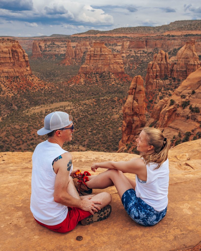
Short and sweet, Otto’s Trail is one of the best easy hikes in Colorado National Monument. If you are short on time and only have time for one hike along the Rim Rock Drive scenic loop, Otto’s Trail is a perfect choice. A short, 40-minute hike leads to one of the most awe-inspiring views of Monument Canyon’s red rock formations, towering sandstone spires, and lush forests in CNM.
Colorado National Monument is located on the Colorado Plateau, in the highest concentration of US National Park units in the country. The Colorado Plateau is home to 9 national parks and 19 national monuments, one of which is Colorado National Monument.
This guide is for you whether you’re hiking Otto’s Trail as part of a bigger Grand Junction itinerary, looking for the best things to do along scenic Rim Rock Drive, or just passing through the area and want to squeeze in a quick visit to Colorado National Monument.


Colorado National Monument Entrance Requirements
Colorado National Monument charges an entrance fee of $25 per vehicle for 7 days. You can also use a national parks pass. We get an America the Beautiful Pass every year since it pays for itself after 3 visits to a national park service site. There are over 2000 locations included in the pass throughout the United States.
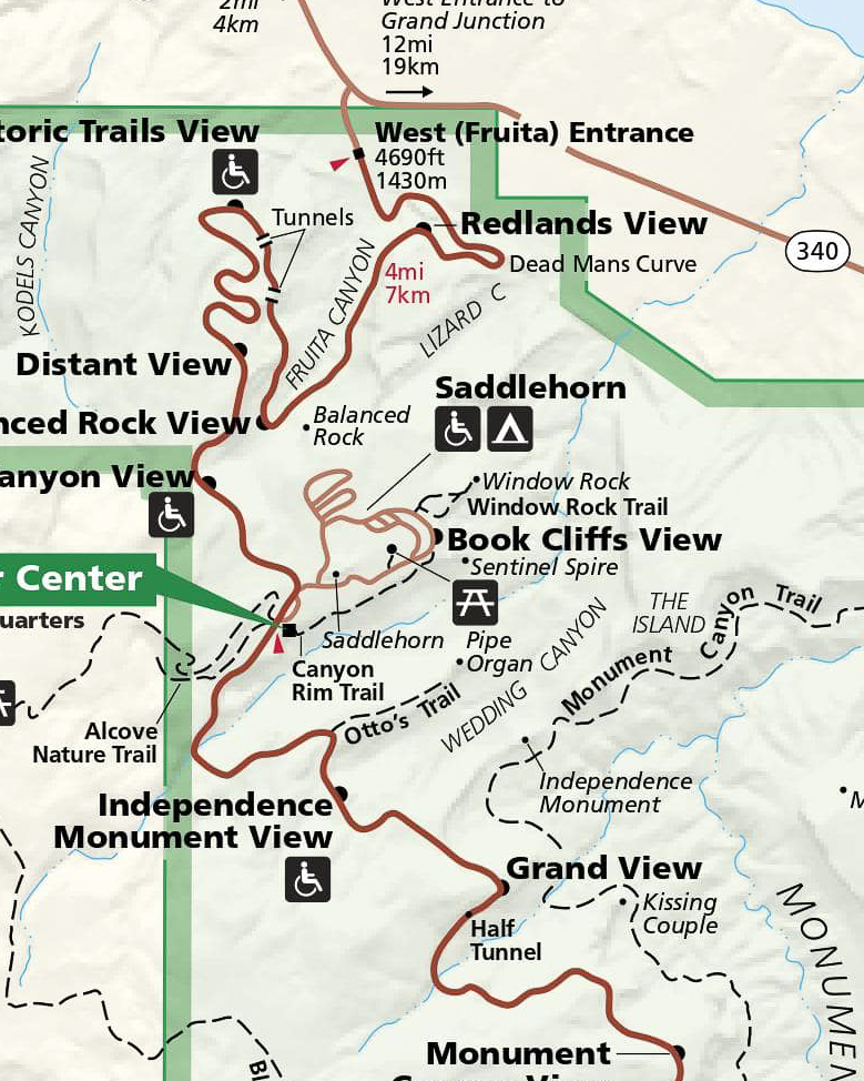
You’ll enter the park at either the east (Grand Junction) or west (Fruita) entrance. It doesn’t really matter which way you go, since Rim Rock Drive (the main road through Colorado National Monument) is two-way.
Otto’s Trail Description
To get to Otto’s Trailhead, you should enter Colorado National Monument by the West Entrance. The trailhead is one mile east of the Saddlehorn Visitors Center, just before you get to the pull-off for the Independence Monument viewpoint. There is a parking area for fewer than 10 cars right by Otto’s Trailhead. Generally, cars are coming and going frequently from here. It is usually not difficult to get a parking spot.
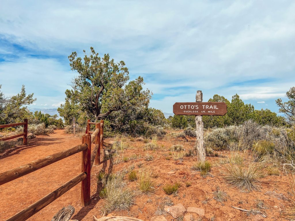
The short, 0.7 miles round trip stroll to Otto’s Viewpoint is one of the best things to do on Rim Rock Drive. The hike takes most people between 20 and 40 minutes round trip with ample time to stop and admire the immersive views.
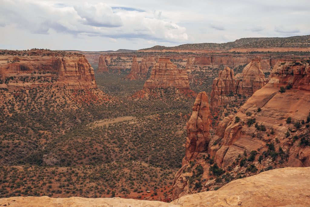
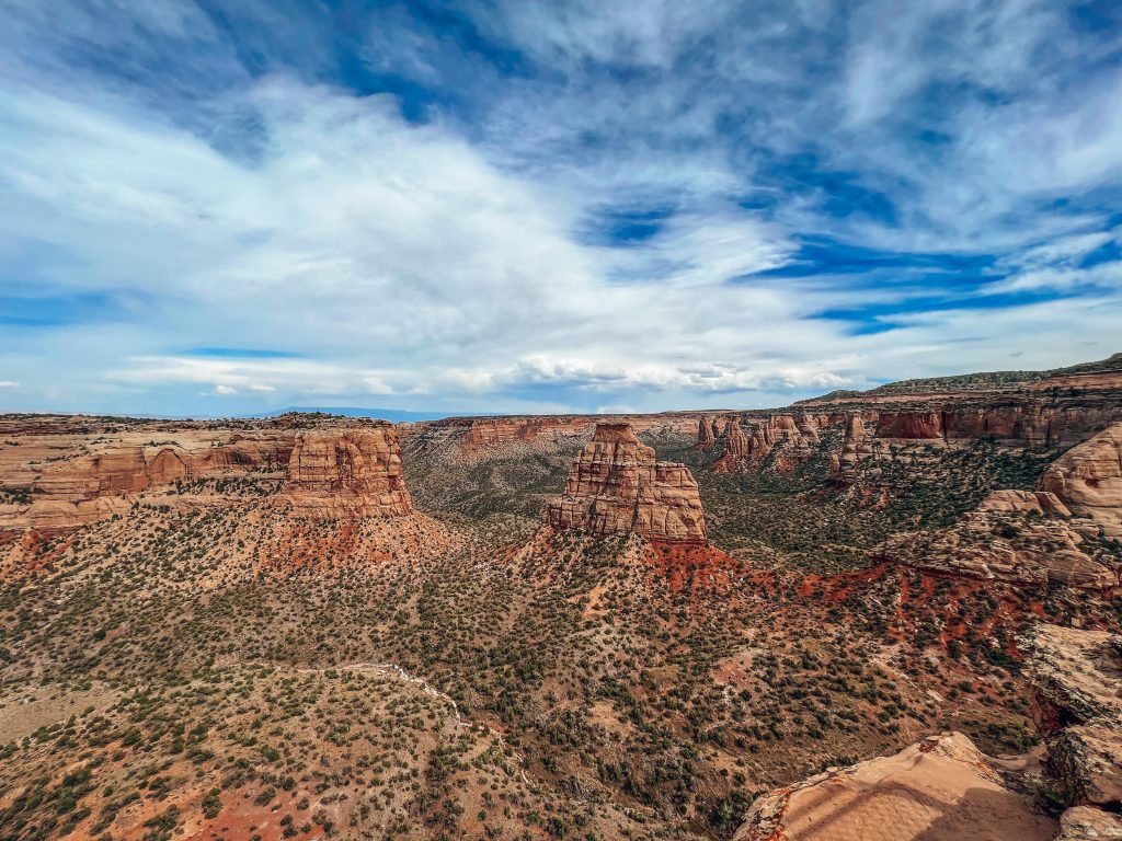
From the trailhead, Otto’s Trail heads east and slightly north onto a peninsula of land jutting into Wedding Canyon. The trail descends gradually to the rim of the canyon, where a protective barrier marks the end of the trail. From here, you have panoramic views of the canyon in all directions. To your left, you can see Pipe Organ, Sentinel Spire, and Window Rock. Wedding Canyon is directly in front of you, just beyond Praying Hands formation. To your right, you can see Independence Monument and Monument Canyon stretching southeast.
Otto’s Trail is well-maintained and clearly marked, making it accessible to hikers of most abilities and ages.

Otto’s Trail Map
Otto’s Trail History
Where does Otto’s Trail get its name anyway? John Otto, for whom the trail is named, was a conservationist and primary advocate for protecting Monument Canyon as a national park. His efforts are what prompted Congress to designate the area as Colorado National Monument in 1911. John Otto then became the first park ranger in CNM. Otto’s Trail leads to an overlook where you can see (among other things) Independence Monument, where Otto married his wife. Their marriage was short-lived, however, as Otto’s passion for wild canyon living was more rugged than what his wife had signed up for in marrying him.

Geology of Otto’s Trail
Otto’s Trail follows a peninsula of land jutting out from along the canyon rim to a viewpoint overlooking Monument Canyon, Wedding Canyon, and notable landmarks like the Pipe Organ, Sentinel Spire, Praying Hands, and Independence Monument. It is one of the most impressive views in Colorado National Monument, a red-rock canyon filled with large rock monoliths on the Colorado Plateau.


Flora on Otto’s Trail
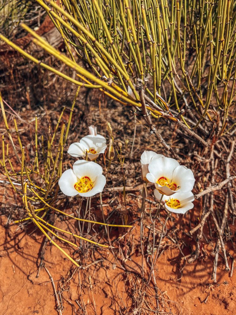
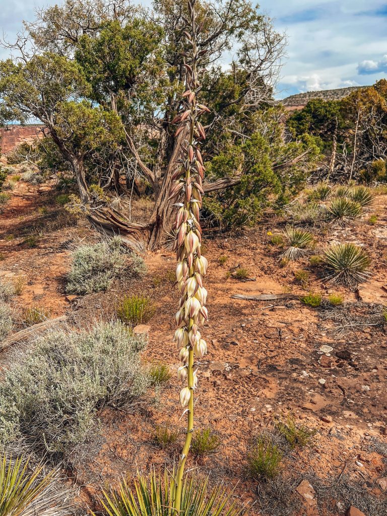
Along Otto’s Trail, you can see many examples of Colorado Plateau desert flora. For example, you can see pinyon pines, sagebrush, and junipers along the trail. We saw beautiful wildflowers when we hiked Otto’s Trail. I later learned these white flowers with the sunburst insides are called sego lillies and are endemic to the western United States.
Where to Stay Near Otto’s Trail
There are a lot of options for where to stay near Otto’s Trail and Colorado National Monument. Saddlehorn Campground is your best option within the park, and the towns of Palisade, Grand Junction, and Fruita are all good options just outside the park.
Saddlehorn Campground
Saddlehorn Campground within Colorado National Monument is definitely the most convenient location to stay when visiting CNM or hiking Otto’s Trail. The campground is located about a mile from Otto’s Trailhead, near the Saddlehorn Visitors Center. You can check Saddlehorn Campground reservations and availability online.
Hotels in Fruita, Palisade, and Grand Junction
Fruita, Palisade, and Grand Junction are all excellent bases for a trip to Colorado National Monument. Fruita and Grand Junction hug either end of CNM, and Palisade is just outside Grand Junction and a great choice for those who want to see Colorado’s wine country as well.
Grand Junction Hotels
- Hotel Maverick
- Courtyard by Marriott Grand Junction
- SpringHill Suites by Marriott Grand Junction Downtown/Historic Main St.
- Fairfield Inn and Suites by Marriott Grand Junction Downtown
- Days Inn by Wyndham Grand Junction
Palisade/Wine Country Hotels
Fruita Hotels
What to Bring to Hike Otto’s Trail
The most important thing to have with you on the short Otto’s Trail hike is water. In the summer, you should carry a gallon jug for each person each day. You should also bring sun protection like hats and sunscreen. Grand Junction and Colorado National Monument get super HOT during the summer, with average daily highs in the 90s degrees Fahrenheit. Yikes!
Otherwise, because the Otto’s Trail hike is very short and relatively flat, you don’t need any specialized equipment. A pair of durable sneakers or hiking shoes and clothes that feel comfortable to you is all you need! Note that winters are cold and summers are hot, with cool temps every night even in the summertime. Your best bet is to pack a lot of layers, like a wool baselayer, a pullover, and a coat or jacket if hiking anytime other than summer. In summer, shorts and T-shirts are sufficient but we still recommend a jacket layer as well.

Final Thoughts on the Otto’s Trail
Otto’s Trail is one of the best short hikes in Colorado National Monument, so we hope you get to check it out on your trip to Grand Junction! While you’re exploring Colorado National Monument, don’t miss scenic Rim Rock Drive or the Coke Ovens Trail and Devils Kitchen Trail.
While you’re traveling in Colorado, why not check out Rocky Mountain National Park? In the heart of the mountains, surrounded by some of the tallest peaks in North America, RMNP is a must-see Colorado bucket list destination. Whether you want to make a challenging hike to an alpine lake or drive one of the highest-elevation roads in the US, Rocky Mountain National Park has an adventure for everyone. Rocky Mountain’s forests and lakes are the perfect contrast to Colorado National Monument’s red rock desert. Click here to check out our Rocky Mountain National Park guides.